

For decades, the Sunshine Coast has been defined by Highway 101. It is a lifeline, a main artery, and for many, our only way to get from Gibsons to Sechelt and up the Coast to Pender Harbour ferry terminal. For those who want to travel without a steering wheel in their hands, the highway is often a source of anxiety rather than a scenic route. Whether you are a cycle-tourist visiting for the weekend or a local resident trying to get to school, relying on a narrow, debris-strewn shoulder while heavy traffic roars past is a major deterrent.
This is exactly what the Connect the Coast project is determined to change. Led by Transportation Choices Sunshine Coast (TraC) and the Connect the Coast Society, this initiative is moving beyond “advocacy” and into the realm of professional engineering and regional transformation.
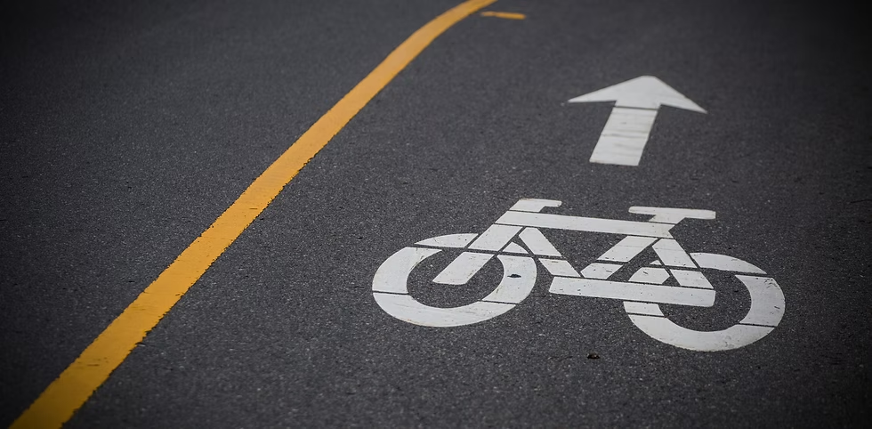
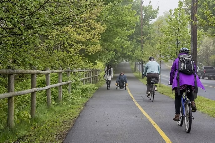
What is “All Ages and Abilities” (AAA)?
The phrase “All Ages and Abilities” is the North Star of this project. It means the goal isn’t just to paint a line on the road for experienced road cyclists in spandex. Instead, the vision is a multi-use path (MUP) that is physically separated from car and truck traffic.
By designing a path that is wide, paved, and protected, the project opens the door for a massive demographic that currently feels “locked out” of active transportation:
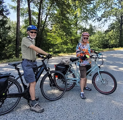
–Parents and Children: Families who want to bike to a friend’s house or a local park without the fear of a car swerving into the shoulder.
–Seniors: Residents using mobility scooters or e-bikes who need a smooth, predictable surface away from high-speed traffic.
–Commuters: Workers who want to save on gas and reduce their carbon footprint but currently find the highway too stressful for a daily trip.
A Strategic, Segmented Approach
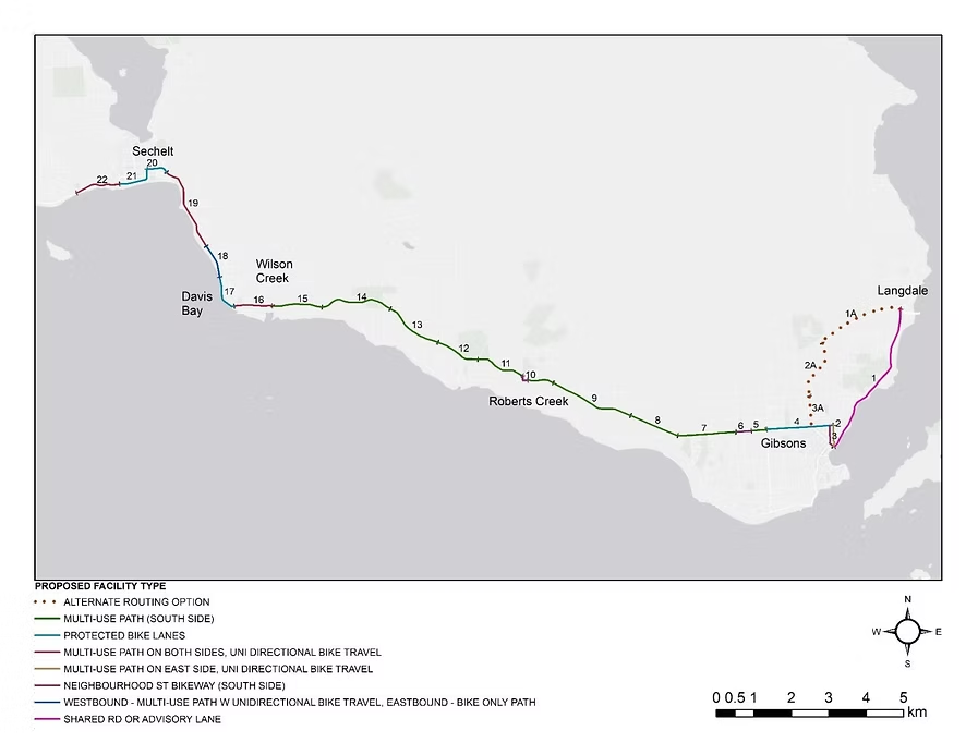
Building a continuous trail from the Langdale ferry terminal to Sechelt (and eventually all the way to Egmont) is a massive undertaking. To make it a reality, the project has been broken down into 25 logical segments. This allows the society to prioritize the areas with the highest safety risks and the highest potential for immediate use.
Currently, the momentum is focused on the “First Priority Segment”: a 2.5-kilometre stretch connecting Pratt Road in Gibsons to Lower Road in Roberts Creek. With conceptual engineering designs now complete and a Class B cost estimate of $9.8 million, the project is no longer just a “nice idea”—it is a rigorously-developed plan waiting for the right provincial and federal investment.
More Than Just a Trail: The Triple Bottom Line
The “Connect the Coast” trail isn’t just about biking; it’s an investment in the Coast’s future across three major pillars:
–Safety & Health: Moving pedestrians and cyclists off the highway shoulder significantly reduces the risk of collisions for all road users. It also encourages a more active lifestyle, which has direct benefits for community physical and mental health.
–Environmental Resilience: Transportation is one of the largest sources of greenhouse gas emissions on the Sunshine Coast. By providing a viable alternative to single-occupancy vehicle trips, we are taking a tangible step toward meeting our climate goals.
–Economic Growth: “Green tourism” is a booming industry. A world-class, separated coastal trail would put BC’s Sunshine Coast on the map as a premier destination for slow-travel tourists, bringing year-round revenue to local cafes, breweries, and B&Bs.
The Road Ahead
The vision for a “Connected Coast” is about choosing what kind of community we want to be. Do we want to remain a region where a car is a requirement for survival, or do we want to become a place where our communities are linked by the quiet whir of a bicycle and the sound of footsteps?
As the Connect the Coast Society continues to engage with the Ministry of Transportation and Transit (MoTT) and local governments, the support of the community is more important than ever. By advocating for this trail, we aren’t just building a path—we are building a safer, quieter, and more sustainable community.
We sat down with Connect the Coast Treasurer Tannis Braithwaite to find out the Who, What, Where, When, and Why’s about the Connect The Coast project from their perspective.
1. “Who are the most critical partners—government, First Nations, or private landowners?—that need to align for the ‘Pratt to Lower Road’ segment to finally break ground, and how can the community help influence those players?”
We are proposing to build public infrastructure on publicly owned land. The government is the critical partner because it functions as the administrative arm of the public. So far, the Connect the Coast project has been advanced by non-governmental organizations, but before the project can go further, a government – either the local governments or the provincial government – must agree to own and operate the project once it is built. That’s where we are at right now. We have a conceptual design for the first priority section that shows how the path can be built and how much it will cost to build, but we can’t move forward without a government being willing to own the infrastructure once it’s completed.
The community can help influence government by talking to their representatives: all of our local government council and board members are familiar with the project, as are our MLA Randene Neill and MP Patrick Weiler. But they need to hear that this path is something people on the Coast really want. The community can also help by participating in any opportunity hosted by gthe overnment to give input on a relevant topic. Participating in things like budget consultations and providing input on changes to official community plans can make a big difference. Mention the need for better active transportation infrastructure in general and for the Connect the Coast trail in particular. Community members can also help by publicizing the project: write a letter to the Coast Reporter, ask TRAC or the Connect the Coast Society to come speak to your community group, talk to your neighbours, write a song about it!
2. “What specific design features are being included to ensure this is truly an ‘All Ages and Abilities’ trail? For instance, how are you handling the steep grades of the Sunshine Coast to ensure the path remains accessible for people on non-electric bikes or in wheelchairs?”
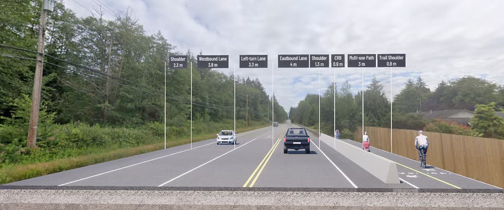
The Province has an “Active Transportation Design Guide” that catalogues the design and engineering requirements for “All Ages and Abilities” active transportation infrastructure, just like it has for building roads. Our proposal is for the Connect the Coast trail to be built within the existing Highway 101 right-of-way, so the trail will have essentially the same grades as the highway. There may be some areas where it is possible to introduce curves (switch-backs) or landing areas (where steeper sections are interrupted by flatter sections), but generally the path will be adjacent to the highway. Overall, we are aiming for a 3 metre wide paved path separated from motor vehicle traffic by a “clear zone” (where there is space in the right-of-way) or a concrete barrier (where there isn’t).
3. “Where is the most challenging ‘bottleneck’ on the route between Gibsons and Sechelt, and what creative engineering solutions are being considered to bypass areas where the highway right-of-way is currently too narrow for a separated path?”
The most challenging area is through Selma Park, both because the right-of-way is very narrow and the geography is very challenging. There are things that can be done to free up space within the existing right-of-way, such as taking out the power poles and moving the power lines underground, or switching from ditch drainage to curb and gutter with storm sewer drainage. But, the only thing you can do to actually widen the right-of-way is buy private property, which is obviously very expensive. We haven’t done a conceptual engineering design for the Selma Park area yet, so we aren’t sure exactly what will be required for the multi-use path to be built in that area, or how much it is likely to cost.
4. “When do you realistically expect construction to begin on the first priority segment, and what is the specific funding or permit milestone that stands in the way of that start date?”
The next step for the first priority section is to complete a detailed engineering design, but before we can do that, we need to secure the agreement of the government that they will own and operate the path once it is built. The owner can be either local governments, with each local government owning the section within its municipal boundary, or the owner can be the Provincial government, which would own the whole thing. This isn’t a decision about who will pay to build the infrastructure or manage its construction; that can be decided separately. It’s a question of who will be responsible for the liabilities associated with the path over the coming decades. Who is going to do the ongoing maintenance work? Who is going to manage legal liability for injuries that happen on the path? That sort of thing.
Estimate a “start date” for construction? A reasonable estimate is one year to find an owner for the path, two years to raise money for a detailed design, two years to complete the detailed design and get permits, two years to raise money for construction, and two years for construction. Given this, it’s possible for the first priority section to be complete by 2035. Or maybe the Province will step up and take over responsibility for building and maintaining the path through its Active Transportation Capital Program. This is a new program that started in 2023 and allows the Ministry of Transportation and Transit to take ownership of and build active transportation infrastructure in highway rights-of-way. We’d love to see this happen, and have been lobbying hard to make it happen, but we don’t know whether the Province will choose to take on the Connect the Coast project. The demand for projects of this kind is huge, and the pot of money the Province has made available is nowhere near enough to meet the demand.
5. “Why should a resident who primarily drives their car support the significant investment required for this trail? How does moving cyclists and pedestrians off the highway shoulder actually benefit the driving experience and the local economy?”
Moving cyclists and pedestrians into their own protected travel space makes Highway 101 safer for everyone. Drivers don’t want to hit pedestrians any more than pedestrians want to be hit by drivers, so preventing this from happening is a win for everyone. And while it’s true that building transportation infrastructure is expensive, it’s not as expensive as having a transportation system that requires everyone to drive. A recent European study found that every kilometre travelled in a private motor vehicle imposes external costs on society valued at $0.17, while every kilometre travelled by foot or by bicycle provides external benefits to society valued at between $0.29 and $0.59. There are benefits in many areas, but one of the biggest benefits is in healthcare costs. Where good active transportation infrastructure is provided, more people travel by active means, which reduces the prevalence and delays the onset of chronic diseases in the population. Preventing even a handful of people from developing a chronic disease or delaying the onset of that chronic disease by 20 years results in millions of dollars in savings to the health-care system. There are similar economic benefits found in delaying capacity expansions to other types of infrastructure. Here on the Coast, getting more people to travel by foot or bike frees up space for cars on the existing highway and the ferry system, and allows BC Ferries and the Ministry of Transportation to delay capacity expansions. Building a kilometre of highway lane costs about 10 times as much as building a kilometre of multi-use path, so there’s really no economic argument for expanding the highway until we try ways to free up road space.
And even more important than the economic argument is the equity piece. People who can’t or don’t want to drive deserve a safe way to move around their communities. Teenagers should be able to safely ride their bikes to school and to their friends’ houses. Their parents shouldn’t have to spend their evenings acting as chauffeurs. Elderly people should be able to get to the grocery store on their mobility scooters without fearing for their lives. Having a transportation system that prioritizes driving to the exclusion of other modes is very unfair.
Building a Better Path Forward
Active transportation projects like “Connect the Coast” represent a fundamental shift in how we design our communities. Moving beyond a car-only mindset isn’t just a luxury—it’s a vital investment in safety, environmental health, and economic resilience. When we prioritize All Ages and Abilities (AAA) infrastructure, we create spaces where everyone, from children to seniors, can move with freedom and dignity.
The technical plans and engineering solutions are often already on the table. The final hurdle is almost always community advocacy and political will. For a project to move from a conceptual design to a physical path, local and regional governments need to know that their constituents value safety and sustainability over the status quo.
How You Can Make an Impact
Infrastructure changes when voices are heard. You can help by:
–Engaging Leaders: Contact your local representatives to voice support for protected, multi-use paths. Visit the BC Cycling Coalition website to learn more about your area.
–Joining the Conversation: Participate in public consultations and community planning meetings to ensure active transportation is a priority.
–Spreading the Vision: Share the benefits of connected trails with your neighbours to build a broader movement for change.
Let’s trade the stress of a narrow shoulder for the safety of a world-class trail. Together, we can build a more connected and sustainable future.